 news
news A tropical disturbance is creeping closer to Florida’s east coast and chances of development have risen significantly.
The National Hurricane Center gives the system, which is located over the northeastern Caribbean Sea, a 90% of formation in the next five days and 80% in the next two days.
“A subtropical or tropical storm is likely to form in the next day or so,” the NHC said. “Regardless of development, there is an increasing risk of coastal flooding, tropical-storm-force winds, heavy rainfall, rough surf, and beach erosion along much of the southeastern United States coast, the Florida east coast, and portions of the central and northwestern Bahamas beginning in the early to middle part of this week.”
This content is imported from Twitter.
You may be able to find the same content in another format, or you may be able to find more information, at their web site.
This content is imported from Twitter.
You may be able to find the same content in another format, or you may be able to find more information, at their web site.
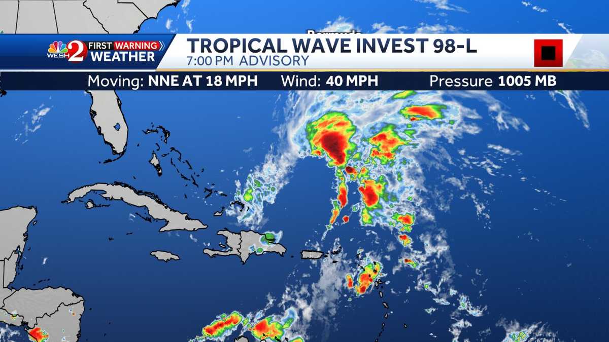
WESH 2 meteorologists say the latest satellite image shows a fairly unorganized system developing, and gradually lifting to the north.
As it lifts north, it will find lower wind shear, warm waters, and a perfect environment for development. When looking at the GFS and Euro models side by side, they both try to develop Invest 98. The Euro keeps it as a tropical storm status, but the GFS brings it to hurricane status and makes landfall somewhere near the Palm Beaches or Treasure Coast. The initial timeline indicates late Wednesday into early Thursday for landfall.
This content is imported from Twitter.
You may be able to find the same content in another format, or you may be able to find more information, at their web site.
This content is imported from Twitter.
You may be able to find the same content in another format, or you may be able to find more information, at their web site.
The concerns are growing for a fairly significant event at the beaches. After Hurricane Ian, so many dunes have been washed out, sea walls heavily damaged.
Related: Tropical disturbance to bring rough weather to hurricane-torn Central Florida coasts
In Volusia County, officials issued a warning Thursday about the storm’s potential to threaten its coastline. They said residents living on the coast should keep a close eye on the disturbance and start preparing right away. County officials there said potential storm impacts include strong rip currents, high surf and breaking waves up to 12 feet.
Emergency management director Jim Judge said because the coast is already so damaged and eroded from Hurricane Ian that “this new system heading our way can significantly threaten those properties with more erosion.”
Further, officials in Volusia County urged residents and visitors to stay off of the beach this weekend into early next week.
KNOW WHAT TO DO WHEN A HURRICANE WATCH IS ISSUED
- Stay tuned to WESH 2 News, WESH.com, or NOAA Weather Radio for storm updates.
- Prepare to bring inside any lawn furniture, outdoor decorations or ornaments, trash cans, hanging plants, and anything else that can be picked up by the wind.
- Understand hurricane forecast models and cones.
- Prepare to cover all windows of your home. If shutters have not been installed, use precut plywood.
- Check batteries and stock up on canned food, first-aid supplies, drinking water and medications.
The WESH 2 First Warning Weather Team recommends you have these items ready before the storm strikes.
- Bottled water: One gallon of water per person per day
- Canned food and soup, such as beans and chili
- Can opener for the cans without the easy-open lids
- Assemble a first-aid kit
- Two weeks’ worth of prescription medications
- Baby/children’s needs, such as formula and diapers
- Flashlight and batteries
- Battery-operated weather radio
WHAT TO DO WHEN A HURRICANE WARNING IS ISSUED
- Listen to the advice of local officials. If you are advised to evacuate, leave.
- Complete preparation activities.
- If you are not advised to evacuate, stay indoors, away from windows.
- Be alert for tornadoes. Tornadoes can happen during a hurricane and after it passes over. Remain indoors, in the center of your home, in a closet or bathroom without windows.
HOW YOUR SMARTPHONE CAN HELP DURING A HURRICANE
A smartphone can be your best friend in a hurricane — with the right websites and apps, you can turn it into a powerful tool for guiding you through a storm’s approach, arrival and aftermath.
Download the WESH 2 News app for iOS | Android
Enable emergency alerts — if you have an iPhone, select settings, then go into notifications. From there, look for government alerts and enable emergency alerts.
If you have an Android phone, from the home page of the app, scroll to the right along the bottom and click on “settings.” On the settings menu, click on “severe weather alerts.” From the menu, select from the most severe, moderate-severe or all alerts.
PET AND ANIMAL SAFETY
Your pet should be a part of your family plan. If you must evacuate, the most important thing you can do to protect your pets is to evacuate them too. Leaving pets behind, even if you try to create a safe space for them, could result in injury or death.
- Contact hotels and motels outside of your immediate area to see if they take pets.
- Ask friends, relatives and others outside of the affected area whether they could shelter your animal.